Bird Watching
The Sites & a Booklet
Many good places for bird watching are within Akureyri and its surroundings. In total there are 11 sites, that all provide favourable conditions, easy access, and services – at the minimum parking, footpaths, information signs about the area and/or hides. Whitin the town limits you find three sites, Krossanesborgir, Naustaborgir and the estuary of the river Eyjafjarðará - called Óshólmar.
A booklet with information on all 11 birdwatching locations in Eyjafjörður was published (2017). The booklet can be seen here .
The Eyjafjörður Region
The nature of Eyjafjörður makes for a good environment for both humans and birds. Extensive wetlands, rivers, marshes and fertile deltas provide a favourable habitat for vegetation and small creatures, which in turn attract migratory birds in their thousands.
Iceland’s global position between temperate and polar zones leads to great biological diversity among small organisms in the ocean north of the island – which are a food source for animals and birds further up the food chain. Eyjafjörður has many fishing villages, and whale-watching cruises operate from a number of places around the fjord.
Eyjafjörður is one of the best areas in Iceland for birdwatching. The Eyjafjarðará, Hörgá and Svarfaðardalsá river estuaries are among the places in Iceland with the greatest variety of bird species. The northernmost place in the country, Grímsey island on the Arctic Circle, has one of Iceland’s most spectacular bird cliffs, with a huge Puffin colony and the second-largest Razorbill colony in the country (the largest is Látrabjarg in the West Fjords).
Eyjafjörður offers a range of organized birdwatching locations, with picnic places, information signs for visitors, marked footpaths and hides for birdwatchers.
Grímsey island
Grímsey island is the northernmost place in Iceland, 41 km north of the mainland. It is located on the Arctic Circle which crosses the island. Grímsey is a part of the municipality of Akureyri. It is served by a ferry (3hrs) from Dalvík on Mondays, Wednesdays and Fridays, and scheduled flights (25min) from Akureyri daily in summer, and three days a week at other seasons. Grímsey is about 5.3 km² in area.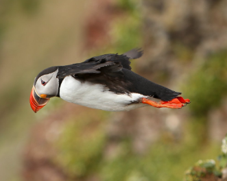 The island has several marked footpaths. We recommend setting off northwards towards the end of the island. The path crosses the Arctic Circle, and on the island you can get a certificate to prove you have been there. A footpath follows the cliff edge around to the Grenivík lighthouse at the southern end of the island. On the way back via the western shore, notice the spectacular formations of columnar basalt projecting into the sea. The route offers a number of excellent locations for bird photography. A large number of Iceland’s bird species are found on the island – as it offers plentiful sources of food for them. Birdlife on Grímsey also benefits from the absence of both rats and foxes.
Grímsey is one of the best places on Iceland’s coast to watch cliff-nesting birds. The birdlife in Grimsey is unique with numerous different species and unusually dense populations. The birdlife is flourishing due to several reasons; rich fishing grounds are close by, no rats or mice are on the island and hunting of the birds and collection of their eggs has been reduced to a minimum since earlier times.
The seabirds generally arrive in March for the breeding season and depart by August. Icelanders traditionally went “climming,” descending birdcliffs on ropes to gather eggs, and this practice continues on Grímsey. In the scree beneath the cliffs is one of Iceland’s biggest Razorbill colonies. Grímsey also boasts the largest Puffin colony on the north coast of Iceland. The Puffin stays on the island from late April until early August, and is easily approachable. Grímsey also has one of Iceland’s largest and densest Arctic Tern colonies.
Grímsey is one of the best places in Iceland for watching cliff nesting birds like; Black-legged Kittiwake (Rissa tridactyla), Northern Fulmar (Fulmarus glacialis), Atlantic Puffin (Fratercula arctica), Razorbill (Alca torda), Black Guillemot (Cepphus grylle) and Murre, both Common Murre or Common Guillemot (Uria aalge) & Thick-billed Murre or Brünnich's Guillemot (Uria lomvia). Commonly seen in Grímsey are also birds like e.g. the White Wagtail (Motacilla alba), the Snow Bunting (Plectrophenax nivalis) and the Northern Wheatear or Wheatear (Oenanthe oenanthe).
The best season for watching birds is from April till August. After that time Migrating birds start to leave the island for warmer places and sea birds head out for the sea. Most of the sea birds stay out on the open sea during the winter, but start returning in the end of February to secure a nesting spot in the densely populated cliffs.
Note! Take good care not to go too near the edge of the costal line as the nest burrowing of the puffins has made the ground loose and hollow in some places.
Hrísey island
Hrísey island, sometimes called “the Pearl of Eyjafjörður,” is the second-largest island off Iceland’s coast, with an area of 7.4 km². From Árskógssandur (road no. 808) a ferry sails to the island every two hours daily. The crossing takes 15 minutes.
Three clearly-marked circular routes of 2.3, 4.5 and 5 km lie through the village and the southern part of the island, where the birdlife is most diverse.
Along the paths are information signs about vegetation, birdlife and other items of interest.
At Lambhagatjörn (Lambhagi Pond), north of the village and less than a km from the harbour, is a hide. Nearly 40 bird species breed on the island, and are densely spaced during the nesting season. The Ptarmigan has a special place among the island’s birds, and features on the community’s official crest. It is a protected species on Hrísey, although it is hunted elsewhere in the country; research has been carried out on the birds for many years. Many Arctic Terns nest on Hrísey, and waders also form dense breeding colonies. The birds benefit from the absence of any wild predators on the island. One of Iceland’s largest colonies of Common Gull is on Hrísey. At the north of the island is an Eider colony which is protected and utilised by the landowners. Access is by permission only.
For an overview of the most common birds in the area.
Krossanesborgir, Akureyri
Krossanesborgir is a nature reserve just north of Akureyri, about 1 km² in area. Moulded by glacial action during the Ice Age, the area is characterised by low rounded rocks with glacial striations, known as whalebacks, interspersed with marshland.
Parking is available at the south of the area, which is reached from Óðinsnes (street name). An entrance sign provides information on birds, vegetation and walking routes. Gravel footpaths lead from the car park through the rock formation, providing options for routes of different lengths.
Along the paths are signs providing information about history, geology, vegetation and birdlife. At Djáknatjörn pond, in the north of Krossanesborgir, about 1.3 km from the car park, is a hide.
About 30 bird species breed in the area, totalling 5-600 pairs. These include a big gull colony and a large number of Ptarmigan. In addition many species of waders, waterfowl and passerines breed here. Among species found there are: Arctic Tern (Sterna paradisaea), Black-headed Gull (Larus ridibundus), Herring Gull (Larus argentatus), Lesser Black-backed Gull (Larus fuscus) and Mew Gull (Larus canus), Black-tailed Godwit (Limosa limosa), various ducks and Gees such as Northern Pintail (Anas acuta) and Greylag Goose (Anser anser) as well as many other species of birds. Attached is an overview of the most common birds in the area.
The best way to get direct to Krossanesborgir is to take a taxi. Bus routs are on googlemaps, all local town buses exit from town center and some go towards the area (but not all the way). Check e.g. bus number 4 (for schedule) or bus number 3 (for schedule) and go out at Hlíðarbraut or Miðsíða and walk from there. It will take about 20 minutes.
Naustaborgir, Akureyri
Naustaborgir is a cluster of tall rocky formations north of the campsite at Hamrar. To the west is grassy marshland, and the Hundatjörn pond, which was drained in the 1940s, but reclaimed in 2007 by damming.
A path about 3 km long leads through the area from the Naustahverfi district of Akureyri, south of the Jaðar golf course. At the end of Ljómatún (street name) parking is available. A hide is located about 1 km from there.
Waders, Black-headed Gulls and ducks nest at Hundatjörn, while passerines nest in the varied woodland around it, including such species as Redwing, Redpoll, Wren and Goldcrest – a recent arrival and the smallest Icelandic bird.Overview with the most common birds in the area.
To get to Naustaborgir you can either take a taxi. Bus routs are on googlemaps, all local town buses exit from town center and some go towards the area (but not all the way). Check e.g. bus number 1 (for schedule) and go out at Kjarnagata/Naustaskóli (The elementery school Naustaskóli). From there you have to walk about 5-10 minutes to the parkingarea and the beginning of the paths.
Óshólmar delta, Akureyri
Deltas are relatively few in Iceland, and almost all are in the north. The largest is the Eyjafjarðará river delta. The area forms the low point of 20 km of lowland along the river banks, formed by fluvial sedimentation since the end of the Ice Age. The lowest part of the area comprises extensive mudflats which are exposed at low tide, providing a feast for numerous bird species. The Ring Road (no. 1) crosses Eyjafjörður at the mudflats (Leiran). While the delta and mudflats have suffered encroachment by transport infrastructure in recent years (such as airport and road construction), they remain one of Iceland’s most important habitats for thousands of wetland birds which migrate there every year.
The old road across the delta, now closed to motor traffic, is a popular route with joggers and walkers. An entrance sign is located on Eyjafjarðarbraut vestri (no. 821) at the south of the airport. From there it is possible to walk to a hide at Stóri-Eyrarlandshólmi (2.5 km), or cross the three old bridges over the Eyjafjarðará river (3.5 km) to Eyjafjarðarbraut eystri (no. 829) on the eastern side of the fjord.
The Leiruvegur road (no. 1) and Eyjafjarðarbraut eystri (no. 829) provide good views over the Leiran mudflats. Cars can be parked in lay-bys along Eyjafjarðarbraut eystri (no. 829).
30-40 bird species breed in the area, or about 40% of all the species that nest in Iceland, while others pass through. The Black-headed Gull (Larus ridibundus) and Eider (somateria mollissima) are the commonest species, followed by the Arctic Tern (Sterna paradisaea), Greylag Goose (Anser anser), and various waders and ducks, such as the Common Snipe (Gallinago gallinago), Whimbrel (Numenius phaeopus), Eurasian Wigeon (Anas Penelope) ect.
Four species in the area are on the Icelandic Institute of Natural history red list i.e. Greylag Goose (Anser anser), Northern Shoveler (Anas clypeata), Northern Pintail (Anas acuta) and Mew Gull (Larus canus). An overview of the most common birds in the area.
To get there, take a taxi. Bus routs are on googlemaps, all local town buses exit from town center and some go towards the area (but not all the way). Check e.g. bus number or a bus number 5 (for schedule) and go out at the skating rink. From there you have to walk about 20 minutes to the start of the trail.